
4400 Massachusetts Ave., N.W.
Washington, D.C. 20016
(202) 885-1470
25 Yards - 8 Lanes
21105 Coopers Hawk Dr
Ashburn, VA 20148
(571) 627-4999
25 yards - 10 lanes
50 meters - 10 lanes
8100 Braddock Road
Annandale, VA 22003-4632
(703) 321-7080
25 Yards - 6 to 10 Lanes
The pool is located in Wakefield Park
14000 Jericho Park Rd.
Bowie, MD 20715
301 - 860-4739
25 yards - 8 lanes
10371 Central Park Dr
Manassas, VA 20110
(703) 393-2632
25 Yards - 8 Lanes
46105 Loudoun Park Lane
Sterling, VA 20164
571-258-3600
25 Yards - 13 Lanes
25 Meters - 10 Lanes
50 Meters - 10 Lanes
4630 Stonecroft Blvd.
Chantilly, VA 20151
703-817-9407
25 yards - 8 lanes
24950 Riding Center Dr
South Riding, VA 20152
571-258-3456
25 Yards - 13 Lanes
25 Meters - 10 Lanes
50 Meters - 10 Lanes
13820 Old Gunpowder Road
Laurel, MD 20707-3116
(301) 301-362-6060
25Yards - 8 to 18 Lanes
50Meters - 8 Lanes
6601 Telegraph Road
Alexandria, VA 22310-3318
(703) 922-9840
25 Yards - 6 to 10 Lanes
50 Meters - 8 Lanes
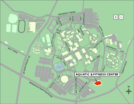
George Mason University -- Prince William Campus
9100 Freedom Center Boulevard
Manassas, Virginia 20110
(703) 993-8444
4400 University Boulevard
Fairfax, Virginia 22030
(703) 993-3939
50 meters -- 8 lanes or 25 yards -- 22 lanes
Parking should be in Lot C on the right approaching the pool (where the campus police and drive-in ATM are located.) Do NOT park in Lot B -- opposite the pool. Reports have been received of $75 parking tickets being given -- even on weekends.
Location of Recreation and Fitness Center on Campus
Location of Parking Lots on GMU Campus
8426 Old Mount Vernon Road
Alexandria, VA 22309
(703) 780-8894
660 22nd Street, N.W.
Washington, D.C. 20006
(202) 676-6409
25 Yards - 8 Lanes
Directions: Capital Beltway (MD), exit Route 29 South, toward Silver Spring. Continue south on Rte 29 to DuPont Circle and New Hampshire Ave. New Hampshire Ave. South around Washington Circle to 23rd Street, N.W., turn left onto F Street, N.W. Turn Left onto 22nd Street, N.W. Pool is at 22nd and F Streets, N.W.
10900 Rockville Pike
North Bethesda, MD 20852
301-493-5000
25 yards - 11 lanes
The Hanley Center for Athletic Excellence The Hanley Center for Athletic Excellence is located on the southwest corner of Prep's campus. When entering campus, stay to the right of the guardhouse and continue on the main road as it loops around campus. Park in the large lot adjacent to the Hanley Center.
18000 Central Park Circle
Boyds, MD 20841-9707
240-777-6830
25 yards - 10 lanes
25 meters - 8 lanes
Link to Map of South Germantown Recreation Park (provided by Montgomery County Receration Department)
540 55th Street NW
Washington, DC 20019
25 Yards - 8 Lanes
814 Ferndale Avenue
Herndon, VA 22070
(703) 787-7300
25 Yards - 8 Lanes
1600 Mine Road
Stafford, VA 2554
(540) 318-6332
25 Yards - 6 to 10 Lanes
50 Meters - 8 Lanes
333 Long Bridge Drive
Arlington, VA 22202
(703) 228-3338
25 Yards - 6 to 10 Lanes
50 Meters - 8 Lanes
8328 Geogretown Pike
McLean, VA 22102-1203
(703) 556-8300
25 Yards - 6 Lanes
Proceed down main entrance road to the security gate. Advise the guard of the PVS event you are attending. After the gate, turn right into the parking lot unless advised otherwise by a security officer. For drop-off only, proceed past the tennis courts on your left and turn left onto the access road that runs behind the sports center, drop-off swimmers at the rear entrance, then continue around and back up to the parking area.
1201 Jackson Road
Silver Spring, MD 20904-2112
(240) 777-8060
25 Yards - 8 Lanes
5900 Executive Boulevard
Rockville, MD 20852-2756
(240) 777-8070
25 Yards - 8 to 16 Lanes
50 Meters - 8 Lanes
2017 Belle View Blvd.
Alexandria, VA 22313
(703) 768-3224
25 Yards - 6 to 10 Lanes
3200 Jermantown Road
Oakton, VA 22124
(703) 281-6501
25 Yards - 8 to 16 Lanes
50 Meters - 8 Lanes
16605 Georgia Avenue
Olney, MD 20832
(240) 777-4995
25 Yards - 8 Lanes
Robert I. Bickford Natatorium
301 Largo Road
Largo, MD 20772
301-322-0980
25 Yards - 8 Lanes
50 Meters - 8 Lanes
8001 Sheriff Road
Landover, MD 20785-4258
301-583-2400
25 yards - 16 lanes
50 meters - 8 lanes
Special Notice: The Prince George's Sports and Learning Complex (PGS&LC) has advised that spectators and participants may no longer park in the lots immediately adjoining the sports complex. Drop-off and pick-up immediately in front of the complex will continue to be possible. Spectators and participants should plan to park in FedEx Field Lot D. From there, a direct path to the front entrance of the complex is available.
FedEx Field Lot D can be reached directly from the Beltway as follows:
Map of PGS&LC and Fed Ex Parking Lots
Prince George's County Sports and Learning Complex Homepage
7525 Marc Drive
Falls Church, VA 22046-7514
(703) 698-1351
25 Yards - 6 to 8 Lanes
13833 Dumfries Road (Door #25)
Manassas, VA 20112
(571) 374-6333
25 Yards - 8 Lanes
25 Meters - 8 Lanes
355 Martins Lane
Rockville, MD 20850
(240) 314-8750
25 Yards - 6 Lanes (Indoor)
25 Yards - 8 to 16 Lanes (Outdoor)
50 Meters - 8 Lanes (Outdoor)
7550 Reservation Drive
Springfield, VA 22153-1362
(703) 866-0566
25 Yards - 6 to 10 Lanes
13601 Missouri Ave
Brandywine, MD 20613
(301)7821-442
25 Yards - 6 Lanes
1239 Spring Hill Road
McLean, VA 22102-2307
(703) 827-0989
25 Yards - 6 to 8 Lanes
300 Van Buren Street St, NW (at
3rd and Van Buren Sts)., NW
Washington, DC 20011
202-576-9284
25 Yards - 16 lanes
50 Meters - 8 lanes
Limited parking is available in lot off 3rd St -- between Tuckerman and Underwood Street. On-street parking is available on 3rd St.or Van Buren St
6508 Industrial Road
Springfield, VA 22151
25 yards - 21 lanes
50 meters - 10 lanes
1100 Michigan Avenue, NE
Washington, DC 20017
202-576-9235
25 yards - 8 lanes
Eppley Recreation Center
University of Maryland
4128 Valley Dr
College Park, Maryland 20742
General facility: 301-226-4500
Aquatic Director: 301-226-5383
25 yards - 8 or 16 lanes
25 meters - 8 or 16 lanes
50 meters - 8 lanes
There may be a charge at certain times/events for using the lower lot, Terrapin Trail Garage or other university lots. Terrapin Trail Garage is free on weekdays after 4pm, and all day Saturday and Sunday, unless an event is happening.
Please visit the UMD Department of Transportation website at www.dots.umd.edu for additional parking information and campus maps.
1325 S. Dinwiddie Street
Arlington, VA 22206
(703) 228-2395
25 Yards - 8 Lanes
The Aquatics Center is located within the School and can be accessed from the main parking lot.
800 Waterloo Road
Warrenton VA 20186
(540) 349-2520
1300 Quincy Street
Arlington, VA 22201
(703) 525-9465
25 Yards - 6 Lanes
635 North Carolina Ave., S.E.
Washington, D.C. 20003-4309
(202) 724-4495
25 Yards - 8 Lanes
Metrorail: Capitol East is only a two block walk from the Eastern Market station of Metrorail. The Eastern Market Station is on the Orange and Blue lines and is at the intersection of 7th St SE and Pennsylvania Ave. Upon exiting the station (cross Pennsylvanvia Ave -- walking north) and go north on 7th St two blocks to North Carolina. Turn left and Capitol East will be on you left once you go past Eastern Market. However, please note Metrorail does not open until 7:00 AM on Saturday and Sunday. See WMATA homepage for additional information.
Special Note:There is no parking lot at Capitol East. Allow time for on street parking. Do not park in the Eastern Market lot on the east side of the pool.
4551 Fort Drive, NW
Washington, DC 20016
202-730-0583
25 Yards - 16 lanes
50 Meters - 8 lanes
Parking is available on surrounding streets.
The Aquatic Center is one block from the Tennleytown Metro Station on the Red Line
5200 Yorktown Blvd.
Arlington, VA 22207
(703) 228-8754
7319 Lee Highway
Falls Church, VA 22042
(703) 560-1430
6030 Lee Highway
Arlington, VA 22005
703-532-7819